| ....................................................................................................................................................... |
|
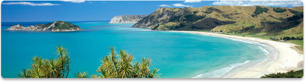
Based on a submerged platform of ancient formation, the Fiji Islands are largely the product of volcanic action, sedimentary deposit, and formations of coral. Viti Levu, the largest island, has an area of about 10,429 square kilometers and accounts for more than half of the Fiji Islands' land.
A rugged dividing range, the Nakauvadra, running from north to south has several peaks above 914 metres (3,000 feet), the highest being Mount Tomanivi (formerly Mount Victoria) at 1322 metres (4,341 feet). The main river systems the Rewa, Navua, Sigatoka, and Ba all have their source in the central mountain area. To the southeast and southwest, and to the south where the range divides, the mountains give way to plateaus, then lowlands. The coastal plains in the west, northwest, and southeast account for only 15 percent of Viti Levu's area but are the main centres of agriculture and settlement. Vanua Levu ("Big Land"), the second largest island, has an area of about 5,556 square kilometers.
island's northern coast, away from the mouth of the Dreketi River, the coastal plains are narrow.
Most of the other islands, including the Lomaiviti, Lau, and Yasawa groups, are volcanic in origin, but, like the major islands, they are bounded by coral reefs, offshore rocks, and shoals that make the Koro Sea hazardous for navigation. Other main islands are Taveuni (470 sq km), Kadavu (411 sq km), Gau (140 sq km), and Koro (104 sq km).